(JTWC)
5:30 p.m. Wednesday, Aug. 28, Philippines time: Tropical Storm Podul exited the Philippines area of responsibilty at about 2 p.m., has picked up forward speed and remains on west-northwest course toward forecast landfall in Vietnam early Friday morning. All tropical cyclone warning signals for the Philippines have been canceled. This should be Storm Tracker's final report on Podul.5:15 a.m. Wednesday, Aug. 28, Philippines time:Podul has been upgraded to a tropical storm by the Joint Typhoon Warning Center. It made landfall at 10:40 p.m. Tuesday near Casiguran in Aurora Province in the Philippines’ northernmost main island of Luzon, rapidly crossed the island, then exited Luzon about 3 a.m. into the Lingayen Gulf, according to the national weather authority PAGASA. Tropical Cyclone Warning Signal 2 has been canceled for central Luzon, while TCWS 1 remains raised for much of the island, PAGASA reports. JTWC reports that at 2 a.m., Podul was 125 miles north of Manila, moving west-northwest at 22 mph and had intensified slightly, to 40-mph sustained winds and 52-mph gusts. If Podul stays on its current heading, it’s forecast to continue west, peaking at 58-mph sustained winds and 75-mph gusts as it clips the southeast coast of China’s Hainan Island early Friday morning. Secondary landfall over Vietnam is forecast for early Saturday morning, with Podul passing 138 miles south of Hanoi about mid-afternoon Saturday, still packing maximum forecast intensity.
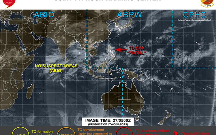
7:15 p.m. Tuesday, Aug. 27, Philippines time: Tropical Depression Podul is still struggling to develop and intensify as it moves quickly west-northwest toward overnight passage over Luzon and a near-direct hit on Baguio before returning to open water in the South China Sea Wednesday afternoon. At 4 p.m., Podul -- Korean for willow tree -- was 256 miles east of Manila and tracking west-northwest at 18 mph, holding steady at 35-mph sustained winds and 46-mph gusts. Closest point of approach to Clark International Airport is forecast for 84 miles north at 5 a.m. Wednesday. Tropical Cyclone Warning Signal 2 remains up for eastern portions of Luzon and TCWS 1 for the rest of the island, according to the national weather authority PAGASA. If Podul remains on its present heading, it's forecast to exit Luzon mid-day Wednesday and enter open water over the South China Sea, peaking at 63-mph sustained winds and 81-mph gusts at mid-afternoon Friday as it skirts the southeastern edge of Hainan Island. Secondary landfall over Vietnam is forecast for Sunday afternoon.12:30 p.m. Tuesday, Aug. 27, Philippines time: Tropical Cyclone Warning Signal 2 has been raised for Isabella, Aurora and Quirino in the Philippines' northernmost main island of Luzon, while TCWS 1 remains raised for other major portions of Luzon, according to the naional weather authority PAGASA. At 8 a.m., Tropical Depression 13W was 333 miles east of Manila, tracking west-northwest at 23 mph and had strengthened to 35-mph sustained winds and 46-mph gusts. If 13W remains on its present heading, it's forecast to make landfall over east-central Luzon, passing 97 miles north of Clark International Airport early Wednesday morning at minimal tropical-storm strength. From there, 13W is due to exit Luzon at mid-morning Wednesday, decrease in intensity initially before strengthening as it approaches southeastern China and Vietnam. 13W is forecast to peak at 63-mph sustained winds and 81-mph gusts as it rounds the southern tip of Hainan island at mid-morning Saturday. Secondary landfall over Vietnam is forecast for late Saturday or early Sunday. 5:15 a.m. Tuesday, Aug. 27, Philippines time: Tropical Depression 13W continues on a west-northwest course toward forecast landfall early Wednesday morning, according to the Joint Typhoon Warning Center. At 2 a.m., 13W was 462 miles east of Manila, tracking west-northwest at 18 mph and holding steady at 29-mph sustained winds and 40-mph gusts. Tropical Cyclone Warning Signal 1 remains raised for most areas of Luzon; that could get raised to TCWS 2 by afternoon or evenng, depending on how much 13W strengthens. If it remains on its current heading, 13W is forecast to make landfall at 2 a.m. Wednesday as a tropical storm, passing 71 miles north of the Clark International Airport at 5 a.m. packing 40-mph sustained winds and 52-mph gusts. This should be more of a rain than wind event for Luzon and Visayas; residents should take precautions, especially those in low-lying areas, for possible flooding and rain-induced landslides. 13W is forecast to weaken as it exits Luzon and heads into the South China Sea, but then strengthen to 52-mph sustained winds and 63-mph gusts as it approaches and clips the southern tip of Hainan Island early Saturday morning. Secondary landfall over Vietnam is forecast for early Sunday morning.11 p.m. Monday, Aug. 26, Philippines time: Say hello to Tropical Depression 13W, forecast to track through Luzon west through the South China Sea through Hainan Island into Vietnam in the next five days. At 8 p.m., 13W was 573 miles east of Manila, tracking west at 23 mph with 29-mph sustained winds and 40-mph gusts. If it stays on its present heading, 13W is forecast to make landfall late Tuesday evening over eastern Luzon at minimal tropical-storm strength, passing 57 miles north of the old Clark Air Base at 3 a.m. Wednesday, packing 40-mph sustained winds and 52-mph gusts at center. 13W should weaken slightly over Luzon, then intensify as it barrels through the South China Sea, peaking at 58-mph sustained winds and 75-mph gusts as it crosses the southern edge of Hainan late Friday, then make secondary landfall 140 miles south of Hanoi late Saturday. Tropical Cyclone Warning Signal 1 remains raised for eastern areas of Luzon, according to the Philippines national weather authority PAGASA. For the Philippines, this will be much more a rain event than a wind event; be prepared for heavy squalls, flooding in low-lying areas and possible landslides.5 p.m. Monday, Aug. 26, Philippines time: 99W Invest remains in tropical cyclone formation alert status according to the Joint Typhoon Warning Center. But the Philippines national weather authority PAGASA has upgraded it to a tropical depression and named it Jenny for local purposes.Tropical Cyclone Warning Signal 1 has been raised for portions of the east coast of the Philippines' northernmost main island of Luzon. At 5 p.m., 99W was 721 miles east of Manila, packing 25-mph sustained winds and 35-mph gusts, and is forecast to move west-northwest, through Luzon into the South China Sea, possibly being designated a tropical depression later Monday by JTWC.2:30 p.m. Sunday, Aug. 25, Philippines time: A tropical cyclone formation alert has been issued on a disturbance labeled 99W Invest. It is forecast to intensify gradually and move in the general direction of Luzon, the Philippines' northernmost main island, over the next couple of days. At 2 p.m., 99W was 1,191 miles east-southeast of Manila. Current model-track guidance indicates movement in Luzon's general direction. Storm Tracker will keep watch.
