Storm Tracker
Tropical Storm 02W (Wutip), # 15 FINAL
Stars and Stripes
February 22, 2019
(U.S. Navy)
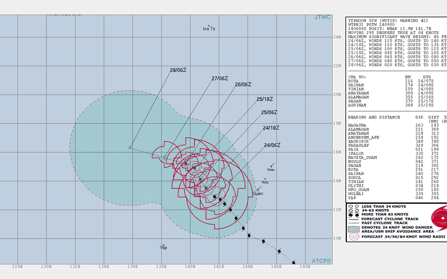
Noon Thursday, Feb. 28, Japan time: February will soon give way to March, and no longer will there remain any month in which there's not been a super typhoon in the Northwest Pacific. Wutip has been downgraded to a tropical storm and continues to die out in the east Philippine Sea. This concludes PST's coverage of Wutip.Noon Tuesday, Feb. 26, Japan time: After less than a day rejuvenated as a super typhoon, Wutip has been downgraded back to a Category 4-equivalent typhoon. Still no threat to land, and it appears as if it will likely die out well southeast of Okinawa. At 1 p.m., Wutip was 1,110 miles southeast of Kadena Air Base and forecast to dissipate by Saturday.Just in case, PST will keep an eye on it.6 p.m. Monday, Feb. 25, Japan time: Until today, only the month of February had never seen in the northern hemisphere a Category 5-equivalent tropical cyclone.Wutip has blown that completely out of the water. It has wavered back and fourth between Category 3 and 4 the past few days -- and it is no threat to any land mass, so relax -- but this afternoon it found a sweet spot in ocean heat content, sea-surface temperatures, atmospheric conditions -- whatever. It's now the strongest storm to hit any northern ocean basin in the second month of the year. At 1 p.m., Wutip was 300 miles west of Guam and was ramping up to 161-mph sustained winds and 196-mph gusts at center. Typhoon-force winds extend 60 miles from center and tropical storm-force winds 195 miles northeast and 160 miles elsewhere, according to the National Weather Service.9:30 p.m. Sunday, Feb. 24, Guam time: All watches and warnings for the Marianas Islands associated with Wutip have been canceled, according to the National Weather Service on Guam.
Wutip has been downgraded from super typhoon to typhoon and is moving northwest away from the Marianas and is no longer a threat to land masses. This concludes coverage of Wutip.
UPDATE 1 p.m. Guam time: Guam has reverted to seasonal Condition of Readiness 4.
10:30 a.m. Sunday, Feb. 24, Guam time: Super Typhoon Wutip continues moving away from Guam, which remains in Condition of Readiness 1 at least through Sunday morning.
According to Joint Region Marianas, emergency and essential services on bases on Guam are open. Check with your base to see what’s open and closed today. Residents are advised to stay indoors until seasonal COR 4 resumes.
Wutip made its closest point of approach at 8 p.m. Saturday, about 165 miles southwest of Guam. Damaging winds of 39 mph are still occurring. A tropical storm warning remains in effect for Guam for now. A high surf warning and a flash flood watch remains in effect. Heavy rains could produce flooding, especially in low-lying areas. Please remain indoors until conditions allow.
1 a.m. Sunday, Feb. 24, Guam time: Rare for this time of year, Wutip has suddenly morphed into a super typhoon and the strongest one on record to threaten the Marianas Islands in the month of February.
But it happened just in time for Wutip to start moving away from Guam. Closest point of approach to Guam has come and gone, though the island remains in Condition of Readiness 1 and a tropical storm warning remains in effect.
At 10 p.m., Wutip was 165 miles west-southwest of Guam, moving northwest at 8 mph, packing 155-mph sustained winds at center. Typhoon-force winds extend 65 miles from center and tropical storm-force winds 215 miles out, according to the National Weather Service.
Given how strong Wutip has become, heavy rain and gusty winds should still rake Guam well into Sunday afternoon. Officials are advising residents to stay indoors until the threat has passed and seasonal COR 4 resumes.
UPDATE 10 a.m. Guam time: While Government of Guam plans to issue Condition of Readiness 1 by 1 p.m., U.S. bases on Guam will remain in TCCOR 2, according to Joint Region Marianas.
7:15 a.m. Saturday, Feb. 23, Guam time: Guam is expected to issue Condition of Readiness 1 by 1 p.m. Saturday, according to Joint Region Marianas, in advance of Typhoon Wutip, which is forecast to remain a Category 3-equivalent typhoon as it passes west of Guam over the weekend.
Wutip’s latest Joint Typhoon Warning Center forecast track shows it has edged a bit further west than before, and storm’s center, and most fierce winds, are expected to remain well offshore as it passes more than 200 miles southwest of Guam early Saturday evening.
At 4 a.m., Wutip was 243 miles south-southwest of Guam, headed west-northwest at 14 mph, still packing 120-mph sustained winds and 150-mph gusts at center. Typhoon-force winds extend 45 miles from Wutip’s center and tropical storm-force winds 185 miles, according to the National Weather Service on Guam.
If Wutip remains on its present track, it’s forecast to pass 213 miles southwest of Andersen Air Force Base and 190 miles southwest of Naval Base “Big Navy” at about 6 p.m. Further than previously forecast.
Though JTWC projects Guam should remain well outside Wutip’s destructive 58-mph (50-knot) wind bands, by no means is Guam out of the woods; hence, why COR 1 is possible by this afternoon. It is still a dangerous Category 3-equivalent storm, and a slight nudge east could make things worse for Guam.
As of now, winds between 35 and 45 mph and gusts up to 55, tropical storm-force winds, are forecast to begin as early as 9 a.m. and continuing through Sunday afternoon. Between 6 to 8 inches of rain are expected; be careful of flooding, especially in low-lying areas. Could be more, could be less. Best to be prepared. Get your safe on, Guam!
2:20 a.m. Saturday, Feb. 23, Guam time: Guam and U.S. military facilities on the island remain in Condition of Readiness 2, according to Joint Region Marianas. A tropical storm warning remains in effect for Guam, according to the National Weather Service.
At 1 a.m., Typhoon Wutip had peaked at 120-mph sustained winds and was 230 miles south of Guam and 355 miles south of Saipan, the NWS reported. Typhoon-force winds extend 45 miles from center and tropical storm-force winds 185 miles.
If Wutip keeps on its present course, the forecast continues to show Wutip remaining off shore as it passes 180 miles southwest of Andersen Air Force Base and 155 miles southwest of Naval Base “Big Navy” late Saturday evening.
Guam could declare COR 1 if Wutip changes course and comes closer to the island, though that’s not expected at the moment. Heavy weather should commence shortly past sunrise Saturday and continue through Sunday as Wutip curves around the island. Stay tuned.
UPDATE 3:30 p.m. Guam time — Guam will set Condition of Readiness 2 at 4 p.m., according to Joint Region Marianas Guam.
UPDATE 10 a.m. Guam time: A tropical storm warning has been issued for Guam, according to the National Weather Service on Guam.
8:30 a.m. Friday, Feb. 22, Guam time: Slightly good news: The center – and full force – of Typhoon Wutip is forecast to remain offshore as it passes Guam over the weekend, according to the Joint Typhoon Warning Center’s latest forecast track.
Still, Guam should experience a gusty, showery weekend as Wutip roars past, as a possible Category 3-equivalent storm, pretty rare for this time of year, but always a possibility. Please prepare accordingly.
At 7 a.m., Wutip was 435 miles south-southeast of Guam and 515 miles south-southeast of Saipan, heading northwest at 10 mph and packing 105-mph sustained winds and 120-mph gusts. Typhoon-force winds extend 50 miles from center and tropical storm-force winds 185 miles, according to the National Weather Service on Guam.
If it remains on its present course, Wutip is forecast to pass 167 miles southwest of Andersen Air Force Base and 143 miles southwest of Naval Base “Big Navy” at 5 a.m. Sunday.
Guam remains in Condition of Readiness 3; expect that to be upgraded Friday afternoon to COR 2. Time to prepare for Wutip is now. Stay tuned.
1 a.m. Friday, Feb. 22, Guam time: The news continues getting gradually worse for Guam, as the latest forecast track for Typhoon Wutip takes it slightly closer to the island, and model guidance is in much better agreement on close passage to Guam over the weekend.
U.S. bases on Guam remain in Tropical Cyclone Condition of Readiness 3, according to Joint Region Marianas. Guam Homeland Security/Office of Civil Defense reports that acting governor Joshua F. Tenorio plans to issue Condition of Readiness 2 for Guam by 4 p.m. Friday.
Guam public schools plan to dismiss students at 1 p.m. Friday in advance of Typhoon Wutip. Joint Region Marianas reports that DODEA schools will remain open during normal school hours.
At 10 p.m., Wutip was 515 miles south-southeast of Guam and 590 miles south-southeast of Saipan, packing 95-mph sustained winds and 120-mph gusts at center, according to the National Weather Service on Guam. Typhoon-force winds extend 35 miles from center and tropical storm-force winds 165 miles.
If Wutip remains on its current Joint Typhoon Warning Center forecast track, it’s due to pass 150 miles southwest of Andersen Air Force Base and 125 miles southwest of Naval Base “Big Navy” between 1 and 2 a.m. Sunday.
Destructive 58-mph winds are not forecast for Guam at this time, but that could change; there is still a 575-mile spread among model solutions, though model guidance and forecast ensembles now agree on a north and northeast curve around Guam over the weekend, and rather close by. Stay tuned.
2 p.m. Thursday, Feb. 21, Guam time: Wutip has been upgraded to a Category 1-equivalent typhoon by the Joint Typhoon Warning Center and its latest forecast track edges it closer to Guam.
Bases on Guam remain in Condition of Readiness 3, according to Joint Region Marianas, and the main Marianas Islands remain under a tropical storm watch, according to the National Weather Service on Guam.
At 1 p.m., Wutip was 600 miles southeast of Guam, headed west-northwest at 13 mph, packing 75-mph sustained winds and 92-mph gusts. NWS reports typhoon-force winds extend 35 miles from center and tropical storm-force winds 165 miles south and 115 miles north.
Wutip is forecast to pass 160 miles southwest of Andersen Air Force Base and 135 miles southwest of Naval Base “Big Navy” just past midnight Sunday.”
7 a.m. Thursday, Feb. 21, Guam time: Tropical Storm Wutip is approaching Category 1-equivalent typhoon strength; it is expected to reach that sometime later Thursday.
Guam is expected to set Condition of Readiness 3 at 8 a.m., according to Joint Region Marianas. In COR 3, destructive winds of 58 mph or greater are possible within 48 hours. Wutip is forecast to pass southwest of Guam late Saturday evening.
Also, a tropical storm watch is in effect for Guam, Rota, Tinian and Saipan as of 7:30 a.m., according to the National Weather Service on Guam.
At 5 a.m., Wutip was 675 miles south-southeast of Guam, moving almost due west at 13 mph, packing 70-mph sustained winds and 85-mph gusts, according to the Joint Typhoon Warning Center.
Tropical storm-force winds extend 185 miles southwest of center and 150 miles elsewhere, according to the National Weather Service on Guam.
If Wutip keeps on its present course, it’s forecast to pass 195 miles southwest of Andersen Air Force Base and 170 miles southwest of Naval Base “Big Navy” around 11 p.m. to midnight Saturday, JTWC forecasts.
There remains a spread of some 450 miles among model solutions, JTWC reports, so much could change. Stay tuned.
7:30 p.m. Wednesday, Feb. 20, Guam time: The bad news remains that Wutip is forecast to peak at Category 3-equivalent strength as it passes Guam over the weekend, according to the Joint Typhoon Warning Center.
The good news, if there is such a thing regarding typhoons, is that Wutip remains forecast to pass well to the southwest of Guam, far enough that the island should remain clear of Wutip’s forecast sustained 50-knot (58-mph) winds. Still, Wutip is expected to be close enough to bring gusty winds and rain squalls and make for a miserable weekend.
At 7 p.m., Wutip was 815 miles southeast of Guam and 860 miles southeast of Saipan, packing 52-mph sustained winds and 63-mph gusts, a fairly strong punch for a one-day-old storm. Tropical storm-force winds extend 150 miles north and 85 miles south of center, according to the National Weather Service on Guam.
If Wutip remains on its present course, it’s forecast to pass 206 miles southwest of Andersen Air Force Base and 181 miles southwest of Naval Base “Big Navy” at 2 a.m. Sunday, JTWC reports. Model guidance and projections by the GFS and CMC forecast ensembles have changed little; there remains quite a spread among model solutions at this point. Stay tuned.
8:30 a.m. Wednesday, Feb. 20, Guam time: It doesn't happen all that often in the winter months. But a Category 3-equivalent typhoon could pass southwest of Guam late Saturday, according to the Joint Typhoon Warning Center.
At 7 a.m., Tropical Storm Wutip was 940 miles southeast of Guam and 970 miles southeast of Saipan, headed almost due-west at 15 mph with 40-mph sustained winds and 52-mph gusts. Tropical storm-force winds extend 155 miles from center, according to the National Weather Service.
If Wutip keeps on its present course, it's forecast to pass 183 miles southwest of Naval Base "Big Navy" and 207 miles southwest of Andersen Air Force Base at about midnight Saturday.
U.S. bases on Guam remain in seasonal Condition of Readiness 4. Joint Region Marianas is already cautioning residents to take precautions in advance of Wutip's passage.
It's still far from certain which way Wutip will move in the coming days.
Model guidance shows a sharp divide as Wutip approaches Guam. The GFS forecast ensemble still indicates a curve close to Guam, then northeast, while the CMC ensemble remains all over the lot. JTWC favors a flat track southwest of Guam without a curve scenario. Hard to tell at this point. Stay tuned.
7:30 p.m. Tuesday, Feb. 19, Guam time: An initial warning on Tropical Depression 02W has been issued by the Joint Typhoon Warning Center, and the first track indicates passage about 200 miles southwest of Guam late Saturday.
At 7 p.m., 02W was 1,075 miles southeast of Guam, headed west at 15 mph, the National Weather Service on Guam reports.
If it remains on its current JTWC forecast track, 02W is due to pass 201 miles southwest of Naval Base "Big Navy" and 224 miles southwest of Andersen Air Force Base between 6 and 7 p.m. Saturday as a Category 2-equivalent typhoon.
U.S. bases on Guam remain in seasonal Condition of Readiness 4. Guam is in an area where tropical cyclones can form quickly, sometimes without warning; therefore, it remains in COR 4 year-round.
Model guidance is mixed at the moment, with the GFS forecast ensemble's best track indicating close passage to Guam, and the CMC ensemble pretty much spread all over the lot, though the best track somewhat agrees with GFS.
Point being, it's way too early in the life of a storm to offer definitive guesses. Stay tuned.
5 p.m. Monday, Feb. 18, Guam time: A tropical cyclone formation alert has been issued on a new disturbance well to Guam’s east-southeast by the Joint Typhoon Warning Center.
At 4:45 p.m., 92W Invest was 863 miles east-southeast of Chu’uk in the Micronesian islands and 1,397 miles east-southeast of Guam, headed west-northwest at 9 mph.
Predictions on what 92W will do differ sharply depending on which models one follows, according to JTWC.
Model guidance shows a west-northwest track in Guam’s general direction, with Global Forecast System being the most aggressive, indicating a turn north and northeast around Guam a week from today.
The GFS forecast ensembles indicate the same, while the Global Ensemble Prediction System favors a track straight northwest past Guam.
It’s very early in the life of a developing storm system to say definitively which way it might go, if it does develop into something significant.