(U.S. Navy)
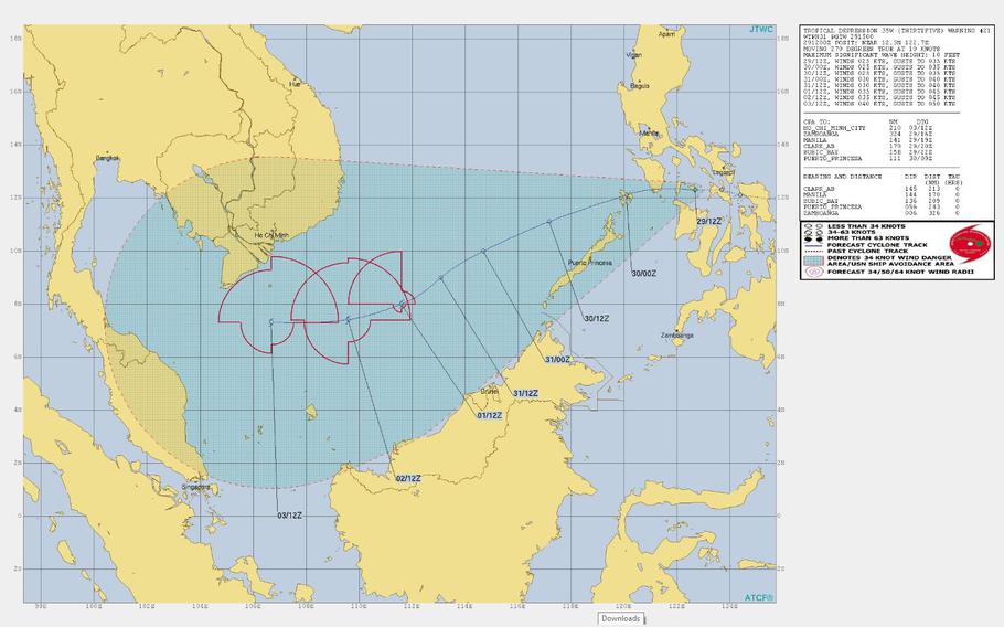
11 a.m. Sunday, Dec. 30, Philippines time:Joint Typhoon Warning Center has issued its final warning on Tropical Depression 35W, which continues to weaken as it moves west toward Palawan Island, weakening as it exits the Philippines area of responsibility. This will be Pacific Storm Tracker’s final report on TD 35W. There's every chance that its remnants could merge with developing system 97W Invest to 35W's southwest. Stay tuned.
11:15 p.m. Saturday, Dec. 29, Philippines time: 35W continues to cling to life as a tropical depression, making its way through Visayas toward the South China Sea, where it could enjoy a second life as a tropical storm according to the Joint Typhoon Warning Center.
At 8 p.m., 35W was 196 miles southeast of Metro Manila, headed west at 12 mph with 29-mph sustained winds and 40-mph gusts.
35W is forecast to arc southwest, passing 162 miles south of Manila at 3 a.m. Sunday, then 128 miles northwest of Puerto Princesa on Palawan about 14 hours later if it maintains forward speed.
JTWC projects 35W to turn west Monday into Tuesday and peak at 52-mph sustained winds and 63-mph gusts as it passes 242 miles south of Ho Chi Minh city in Vietnam about 7 p.m. Thursday.
11 a.m. Saturday, Dec. 29, Philippines time: All tropical cyclone warning signals related to Tropical Depression 35W have been lifted for the central Philippines, according to national weather authority PAGASA.
35W, named Usman by PAGASA, has also been downgraded to a low-pressure area by PAGASA, while it remains a tropical depression according to the Joint Typhoon Warning Center.
At 8 a.m., 35W was 305 miles southeast of Metro Manila, moving west-northwest at 15 mph and holding steady at 35-mph sustained winds and 46-mph gusts, JTWC reports.
If it maintains present heading, JTWC forecasts 35W to remain a tropical depression until late Sunday evening after it makes its way back over water in the South China Sea, where it's forecast to strengthen into a tropical storm.
11 p.m. Friday, Dec. 28, Philippines time: Tropical Depression 35W continues its slow crawl west toward Samar in the Philippines, with landfall forecast for sometime early to mid Saturday morning, according to the national weather authority PAGASA.
Tropical Cyclone Warning Signal 1 remains in effect for major portions of Visayas, southern Luzon and the Dinagat Islands in Mindanao, PAGASA reports.
At 8 p.m., 35W, named Usman by PAGASA, was 476 miles east-southeast of Metro Manila and 133 miles east of Guiuan in Eastern Samar, moving almost due west at 7 mph, holding steady at 35-mph sustained winds and 46-mph gusts, according to the Joint Typhoon Warning Center.
If it maintains its present heading, 35W is forecast to remain at tropical depression- or weak tropical storm-strength over the next two days as it makes its way west through the Visayas, past Palawan into the South China Sea.
JTWC projects 35W to pass 246 miles south of Manila at 11 p.m. Saturday and 67 miles northeast of Puerto Princesa at mid-day Sunday as a tropical storm.
JTWC, model guidance and the GFS forecast ensemble project 35W to next edge south through the South China Sea, 317 miles south of Ho Chi Minh City at 7 p.m. Wednesday, then through the Malay peninsula into the Bay of Bengal, peaking at 52-mph sustained winds and 63-mph gusts.
11:15 a.m. Friday, Dec. 28, Philippines time: Tropical Depression 35W continues edging closer to the Philippines' Visayas region and is forecast to make landfall over eastern Samar on Friday evening, according to the national weather authority PAGASA.
At 8 a.m., 35W, named Usman by PAGASA, was 143 miles east of Guiuan in eastern Samar and 543 miles east-southeast of Metro Manila, moving west at 7 mph and had strengthened slightly, to 35-mph sustained winds and 46-mph gusts.
If 35W remains on its present heading, it's forecast to pass 256 miles south of Manila about 7 p.m. Saturday and could strengthen into a tropical storm before making landfall Friday evening, according to PAGASA and local news reports.
Joint Typhoon Warning Center projects 35W to intensify as it moves west away from the Philippines into the South China Sea. PAGASA projects 35W to exit the Philippines' area of responsibility Sunday evening or Monday morning.
Model guidance continues to depict a straight run west, followed by a turn northwest toward the Gulf of Thailand. The GFS forecast ensemble shows 35W edging slightly south of Vietnam before tracking into the Bay of Bengal, while the CMC ensemble concurs with model guidance on a straight run west, grazing Vietnam's southern tip.
11 p.m. Thursday, Dec. 27, Philippines time: Little change regarding Tropical Depression 35W. Tropical Cyclone Warning Signal 1 remains raised for Visayas, southern Luzon and Dinagat Island, according to the Philippines' national weather authority PAGASA.
At 8 p.m., 35W was 618 miles east-southeast of Metro Manila, moving west-northwest at 8 p.m. and still holding at 29-mph sustained winds and 40-mph gusts.
If 35W, named Usman by PAGASA, remains on its present heading, it's forecast to pass 213 miles south of Manila at 3 p.m. Saturday, then continue west into the South China Sea, exiting the Philippines' area of responsibility sometime Sunday night or Monday morning.
GFS model guidance now shows a straight run west over the southern tip of Vietnam, with NAVGEM being a northwest outlier.
GFS and CMC forecast ensembles each concur on a track generally west into the South China Sea.
Joint Typhoon Warning Center projects 35W to peak at 52-mph sustained winds and 63-mph gusts late Monday into early Tuesday.
11:20 a.m. Thursday, Dec. 27, Philippines time: Tropical Cyclone Warning Signal 1 has been raised for most of eastern and central Visayas, parts of southern Luzon and Dinagat Island in northern Mindanao, according to the Philippines weather authority PAGASA.
Moderate to heavy rains caused by Tropical Depression 35W (Usman) may trigger flooding and landslides and are expected to affect Bicol region, eastern Visayas and Dinagat, PAGASA reported.
At 10:45 a.m., 35W was 578 miles east-southeast of Metro Manila, moving west-northwest at 12 mph, continuing to hold steady at 29-mph sustained winds and 40-mph gusts.
If 35W maintains its present course, it's forcast to pass 200 miles south of Manila at 8 a.m. Saturday, packing 40-mph sustained winds and 52-mph gusts.
35W is due to exit the Philippines area of responsiblity sometime Monday, then peak at 52-mph sustained winds and 63-mph gusts as it rumbles west through the South China Sea.
Model guidance and the GFS and CMC forecast ensemble best tracks remain in agreement on a track through central Visayas, into the South China Sea and southwest, missing Vietnam entirely and heading into the Gulf of Thailand nine to 10 days from now.
11 p.m. Wednesday, Dec. 26, Philippines time: Tropical Cyclone Warning Signal 1 has been issued for Eastern Samar Island in the Visayas region of the Philippines, according to the national weather authority PAGASA.
10:30 p.m. Wednesday, Dec. 26, Philippines time: Like the skipper of a launch flooring the accelerator, Tropical Depression 35W has picked up forward speed and remains on course to make landfall Friday morning near Tacloban on southern Samar Island as a weak tropical storm.
At 8 p.m., 35W was 721 miles east-southeast of Metro Manila, headed west at 21 mph, still holding steady at 29-mph sustained winds and 40-mph gusts. 35W is due to peak at 40-mph sustained winds and 52-mph gusts as it makes its way ashore at about 8 a.m. Friday.
If 35W maintains its present heading, it's forecast to pass 233 miles south of Manila at about 7 a.m. Saturday, maintaining tropical-depression strength.
Again, this is not about the wind, but the rain. Some reports put the forecast precipitation at as much as 40 inches through Visayas, northern Mindanao and as far north as Manila and perhaps beyond. Flooding in low-lying areas and landslides are possible. Take special care to find safe locations as the weekend approaches.
1:15 p.m. Wednesday, Dec. 26, Philippines time:Tropical Depression 35W has entered the Philippines area of responsibility and has been named Usman by the national weather authority PAGASA.
No tropical cyclone warning signals have been raised yet for the Philippines, though that's expected come Wednesday evening or Thursday morning, PAGASA reports.
35W (Usman) has turned almost due west and has picked up forward speed as it begins to head toward Visayas region. At 1 p.m., 35W was 845 miles east-southeast of Metro Manila, moving west at 12 mph, but holding steady at 29-mph sustained winds and 40-mph gusts.
35W remains forecast to be much more of a rain event than a wind event. Joint Typhoon Warning Center projects 35W to peak at 46-mph sustained winds and 58-mph gusts just before forecast landfall at mid-morning Friday.
If 35W continues moving as forecast, it's due to pass 185 miles south of Manila at mid-afternoon Saturday, weakening as it bisects Visayas and heads back over open water in the South China Sea.
GFS and CMC best tracks continue to favor similar paths across Visayas, followed by a southwest track taking 35W south of Vietnam into the Malay peninsula just south of Thailand nine to 10 days from now.
11 p.m. Tuesday, Dec. 25, Philippines time: Tropical Depression 35W doesn't appear to be in any hurry to visit the Philippines, continuing to lurk 1,000 miles east-southeast of Metro Manila at 10:45 p.m. Christmas Night.
If it remains on its current path, 35W -- as yet unnamed -- is forecast to pass 187 miles south of Manila at 5 p.m. Saturday, and peak only at 46-mph sustained winds and 58-mph gusts, a bit weaker than previously reported.
Again, much more of a rain event than a wind event. Be prepared for heavy showers, accompanied by flooding in low-lying areas and possible landslides as 35W rumbles through Visayas as a middling tropical storm.
Slight disparity in model guidance, with GFS favoring a zig-zag walk as far west as Vietnam. Both GFS and CMC forecast ensembles best tracks agree on a path through the central Philippinesand on into Vietnam.
10:30 a.m. Tuesday, Dec. 25, Philippines time: Merry Christmas, and Maligayang Pasko to PST's friends in the Philippines.
Tropical Depression 35W is having a hard time developing as it approaches the east coast of the Visayas region of the Philippines.
It remains forecast to pass through the region as a middling tropical storm, much more a rain event than a wind event, peaking at 52-mph sustained winds and 63-mph gusts as it makes forecast landfall in southern Visayas.
At 10:15 a.m., 35W was 1,109 miles east-southeast of Metro Manila, headed northwest at 6 mph, holding steady at 29-mph sustained winds and 40-mph gusts.
If it continues moving as forecast, 35W is due to pass about 240 miles south of Manila at about 2 p.m. Saturday, then keep heading west into the South China Sea.
There remains some disparity in model guidance, though GFS and CMC ensembles' best tracks are in tight agreement on paths through central-southern Visayas. Stay tuned.
11:30 p.m. Monday, Dec. 24, Philippines time: The disturbance east of the Philippines has formed into the 35th numbered tropical cyclone of the northwest Pacific’s season. Tropical Depression 35W, as yet unnamed, was 1,116 miles east-southeast of Manila at 11:30 p.m., headed due west at 14 mph.
If it remains on present course, it’s due to become a middling tropical storm late this week, passing about 206 miles south of metro Manila at 11 a.m. Saturday, packing 52-mph sustained winds and 63-mph gusts.
Model guidance is in good agreement; the GFS ensemble best track also depicts a track through Visayas.
35W should be much more a rain event than a wind event. Visayas region should see heavy rain, with localized flooding and landslides possible.
6 p.m. Monday, Dec. 24, Philippines time: Not the sort of present the Philippines would want from Santa Claus, given that it is Christmas Eve.
But the Joint Typhoon Warning Center has issued a tropical cyclone formation alert on system 96W Invest, lurking just east of Palau.
JTWC and model guidance project a track through the central Philippines later in the week.
Global Forecast System forecast ensemble’s best track indicates a path through Visayas within five days, while the Canadian Meteorological Center’s best track favors a path that skims east of Visayas and Luzon, then curves northeast over the next six days.
It’s a wait-and-see game at this point.
