(Joint Typhoon Warning Center)
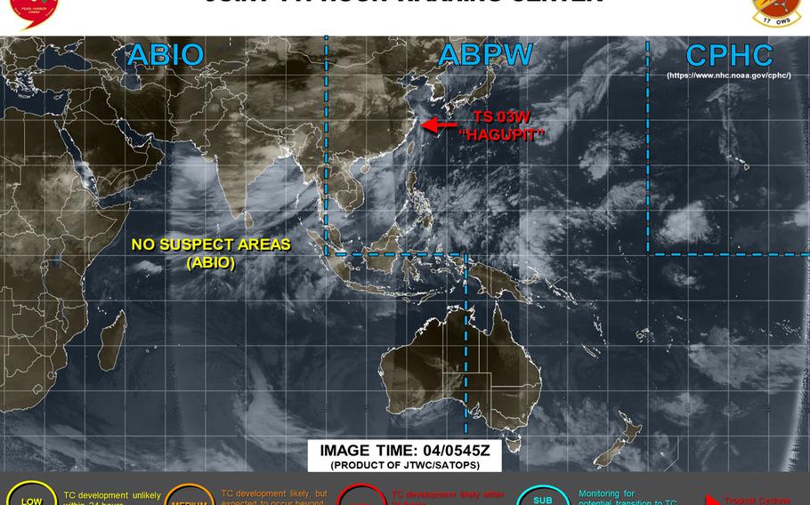
11:30 p.m. Tuesday, Aug. 4, Korea time: Tropical Depression Hagupit continues to weaken as it moves overland in eastern China. It's forecast by Joint Typhoon Warning Center to dissipate as it curves northeast and moves out over the Yellow Sea (West Sea). Gale-force winds are forecast to persist as Hagupit's remnants move northeast. Unless Hagupit regenerates, this is Storm Tracker's final report on Hagupit.6 p.m. Tuesday, Aug. 4, Korea time: That didn't take long at all. Hagupit has been quickly downgraded to a tropical depression by the Joint Typhoon Warning Center and is forecast to die out in the Yellow Sea (West Sea) before it reaches Korea. At 3 p.m., Hagupit was 120 miles southwest of Shanghai, China, moving almost due north at 12 mph and had weakened to 35-mph sustained winds and 46-mph gusts at center. As it traverses the rugged east China terrain, JTWC forecasts Hagupit to keep weakening as it curves northeast into strong wind shear and the cooler waters of the Yellow Sea and dissipate within the next 1 1/2 days.3 p.m. Tuesday, Aug. 4, Korea time: Joint Typhoon Warning Center reports that 93W Invest has dissipated and is no longer suspect for development into a tropical cyclone in the next 24 hours. 1 p.m. Tuesday, Aug. 4, Korea time: If there was ever a good example of how land and typhoons do not get along, Hagupit is a poster-child. Hagupit, which made landfall over Zhejiang province in eastern China during the wee hours Tuesday morning, has been downgraded to a tropical storm by Joint Typhoon Warning Center. And it is rapidly weakening as it battles the rugged east China terrain. At 8 a.m. east China time, Hagupit was 176 miles south-southwest of Shanghai, moving north-northwest at 13 mph and had diminished from Category 1-equivalent status to 52-mph sustained winds and 63-mph gusts at center. JTWC forecasts Hagupit to continue weakening as it moves north, curving northeast into the cooler waters of the Yellow Sea (West Sea) and dissipating well before it reaches the Korean peninsula.Model track guidance and the GFS and CMC forecast ensembles do give Hagupit something of a chance of reaching Korea, but that remains to be seen. It's a struggle between storm and land, and the land is winning at the moment. Down southeast of Mindanao in the southern Philippines, 93W Invest is having struggles of its own developing, as close to land as it is. But it does bear watching, as JTWC continues to label it a "medium" area for developing into a tropical cyclone in the next 24 hours.11:45 p.m. Monday, Aug. 3, Korea time: Hagupit remains a Category 1-equivalent typhoon, but has intensified over the last six hours, packing gusts exceeding 100 mph, according to the Joint Typhoon Warning Center. At 9 p.m., Hagupit was 377 miles west of Kadena Air Base, Okinawa, and had slowed again, moving northwest at 11 mph, packing 86-mph sustained winds and 104-mph gusts, but at storm's center. U.S. bases on Okinawa remain in seasonal Tropical Cyclone Condition of Readiness 4. Hagupit remains forecast to plow ashore over east China overnight Monday, weakening steadily as it moves inland over the rugged China terrain. JTWC and model solutions depict Hagupit curving northeast into the cooler waters of the Yellow Sea (West Sea), passing over Korea north of the DMZ on Thursday as a tropical depression. To the south, a good 1,400 miles south of Kadena, 93W Invest continues to lurk southeast of Mindanao in the southern Philippines as a "medium" area for development in the next 24 hours, according to JTWC. Still eyeing it. Next update at mid-day Tuesday.5:30 p.m. Monday, Aug. 3, Korea time: Say hello to the second typhoon of the season.Hagupit was upgraded to a Category 1-equivalent typhoon Monday afternoon by the Joint Typhoon Warning Center. It remains on course to ram into China's east coast overnight Monday and continue across the Korean peninsula Thursday as a tropical depression. At 3 p.m., Hagupit was 328 miles west of Kadena Air Base, Okinawa, moving northwest at 18 mph and packing 75-mph sustained winds and 92-mph gusts. U.S. bases on island remain in seasonal Tropical Cyclone Condition of Readiness 4.The Associated Press reports that Hagupit is forecast to make landfall between Zhejiang and Fujian provinces in east China early Tuesday morning. Shanghai further north is expected to feel effects. If Hagupit remains on its present course, it's forecast to move over China's rugged eastern terrain, remaining over land for perhaps as long as 36 hours before curving northeast. JTWC projects Hagupit to weaken steadily as it traverses the cooler waters (73 degrees) of the Yellow Sea before crossing the Korean peninsula above the DMZ at mid-day Thursday as a tropical depression.And there's every chance it could dissipate before reaching Korea. Meanwhile, Storm Tracker is also eyeing a disturbance southeast of Davao in Mindanao, the Philippines' largest island. JTWC already has labeled it a "medium" area for development in the next 24 hours. Next update about midnight Monday.12:15 p.m. Monday, Aug. 3, Korea time: Stronger, ever stronger, Tropical Storm Hagupit is becoming. It intensified overnight into Monday to just below typhoon strength. Hagupit is forecast by Joint Typhoon Warning Center to later Monday become the second typhoon of the northwest Pacific's tropical cyclone season behind Vongfong in mid-May. At 9 a.m., Hagupit was 278 miles west-southwest of Kadena Air Base, Okinawa, and had sped up a little, moving north-northwest at 11 mph, packing 69-mph sustained winds and 86-mph gusts at center. Closest point of approach to Okinawa has come and gone, though the island is feeling some gusts from Hagupit's very outer edges. U.S. bases on Okinawa remain in seasonal Tropical Cyclone Condition of Readiness 4.Kadena's weather forecast calls for occasional showers with sustained winds between 13 and 23 mph and gusts between 20 and 28 mph. Those should die down as Hagupit moves on its JTWC forecast track. It's projected to peak at 75-mph sustained winds and 92-mph gusts Monday evening before making landfall early Tuesday morning south of Shanghai over eastern China. From there, it's a battle with the frictional effects of China's rugged terrain. Hagupit is forecast to steadily weaken as it curves northeast, back out over the Yellow Sea (West Sea) and dissipating as it reaches the Korean peninsula just north of the DMZ.Model track guidance, the GFS and CMC forecast ensembles are in better agreement and pretty much mirror the JTWC's forecast track, with a spread of about 120 miles among solutions two days out, JTWC reports.Midnight Sunday, Aug. 2, Japan time: Initially, Tropical Storm Hagupit was forecast to cross the Korean peninsula as a tropical depression. The latest Joint Typhoon Warning Center forecast indicates it could dissipate before it even gets that far. At 9 p.m., Hagupit was 304 miles southwest of Kadena Air Base, Okinawa. It had slowed down somewhat, moving northwest at 8 mph, and was forecast to pass 293 miles southwest of Kadena around midnight. Hagupit had strengthened to 52-mph sustained winds and 63-mph gusts, and JTWC projects Hagupit to peak at 63-mph sustained and 81-mph gusts at mid-morning Monday. But that's at storm's center, quite a way's away from Okinawa. U.S. bases on island remain in seasonal Tropical Cyclone Condition of Readiness 4. As the week unfolds, JTWC forecasts Hagupit to pass just northeast of the tip of Taiwan before making landfall south of Shanghai on China's east coast early Tuesday morning. JTWC's forecast track then depicts Hagupit curving northeast over the cooler waters of the Yellow Sea (West Sea) and dying out as a tropical depression before reaching Korea's west coast.Model track guidance and the GFS and CMC forecast ensembles agree on a track into China followed by a northeast curve. Just a question of how long Hagupit can survive the journey over the rough terrain of eastern China and the relatively cooler northern environment. Next update at mid-day Monday.3:20 p.m. Sunday, Aug. 2, Japan time: Much windblown haze and spot showers and thunderstorms out there over Okinawa. Brought to you by outer bands associated with Tropical Storm Hagupit, which remains forecast to pass well southwest of the island. At 9 a.m., Hagupit, upgraded to a tropical storm overnight by Joint Typhoon Warning Center, was 320 miles southwest of Kadena Air Base. It was moving west-northwest at 14 mph, packing 40-mph sustained winds and 52-mph gusts at center. U.S. bases on Okinawa remain in seasonal Tropical Cyclone Condition of Readiness 4. Kadena's extended forecast calls for scattered showers and east to southeasterly winds peaking at 20-mph sustained and 32-mph gusts Monday afternoon. If Haguput remains on its present course, it's forecast to pass 302 miles southwest of Kadena at about midnight Sunday, then keep tracking northwest toward landfall over China's east coast early Tuesday morning. Frictional effects with China's rugged terrain would take over at that point, with Hagupit weakening as it moves over land and into a relatively cooler environment. JTWC, model track guidance and the GFS and CMC forecast ensembles indicate Hagupit curving northeast across the Yellow Sea (West Sea) as a tropical depression before making secondary landfall somewhere over the Korean peninsula Thursday morning. Next Storm Tracker update about midnight Sunday.UPDATE 11:15 p.m. Saturday, Aug. 1, Hong Kong time: All wind signals associated with Tropical Storm Sinlaku have been canceled by the Hong Kong Observatory. This is the last update on Sinlaku. Next update at mid-day to mid-afternoon Sunday.11 p.m. Saturday, Aug. 1, Hong Kong time: Standby Signal 1 was raised and Strong Wind Signal 3 lowered by the Hong Kong Observatory as Tropical Storm Sinlaku continues headed west-northwest toward forecast landfall in Vietnam at mid-morning Sunday. HKO reported at 10:45 p.m. that winds have greatly diminished and all wind signals should be canceled shortly. Meanwhile, Tropical Depression 03W has been named Hagupit, and remains forecast to continue tracking well west of Okinawa -- 263 miles southwest at about 10 p.m. Sunday -- and toward the east coast of China before curving toward Korea as a tropical depression. U.S. bases on Okinawa remain in seasonal Tropical Cyclone Condition of Readiness 4. Extended forecast remains the same as reported earlier Saturday, with peak winds occurring Monday and rain, showers and possible thunderstorms as the new week begins. There is something of a spread, about 165 miles, among model solutions three days out for Hagupit, according to the Joint Typhoon Warning Center. The main outlier is NAVGEM, which according to model track guidance depicts Hagupit crossing the southern edges of the Korean peninsula. Most other solutions, the GFS and CMC forecast ensembles, show Hagupit bisecting the peninsula just north of the Demilitarized Zone. All this could change. Hagupit is still a very young storm.6:10 p.m. Saturday, Aug. 1, Korea time: Wow. That did not take long. Just as July exited like the proverbial lamb, August appears to be coming in like a lion.Tropical Storm Sinlaku spawned Saturday afternoon just southwest of Hainan Island in southeastern China. It's due to make landfall Sunday evening and pass 45 miles southwest of Vietnam's capital of Hanoi, so it might not be around long. Strong Wind Signal 3 remains raised for Hong Kong, even though Sinlaku is more than 400 miles southwest of the city. As for Tropical Depression 03W, it remains forecast to head northwest, passing 266 miles southwest of Kadena Air Base, Okinawa, at about 10 p.m. Sunday as a tropical storm, 52-mph sustained winds and 63-mph gusts. That's at storm's center, though, well away from the island.Kadena's long-range forecast calls for Okinawa to experience peak winds on Monday once 03W has passed, southeasterly 21-mph sustained winds and 29-mph gusts with up to 50-percent chance of rain and showers. U.S. bases on island remain in seasonal Tropical Cyclone Condition of Readiness 4. Joint Typhoon Warning Center forecasts 03W to track northwest and make landfall just south of Shanghai overnight Monday, then weaken before curving northeast. JTWC's extended track brings 03W just short of the Korean peninsula Wednesday afternoon as a tropical depression.Model track guidance and the GFS and CMC forecast ensembles still depict something of a spread in solutions. Keep in mind, 03W is young yet. Much can change over five days. If 03W becomes a named story, it would be called Hagupit, a Tagalog word meaning to lash or flog. Sinlaku is Micronesian for a legendary goddess native to Kosrae.1:50 p.m. Saturday, Aug. 1, Korea time: Disturbance 92W Invest has become the third numbered storm of the northwest Pacific's tropical cyclone season.Tropical Depression 03W was 453 miles south of Kadena Air Base, Okinawa at 9 a.m., moving north-northwest at 21 mph. Joint Typhoon Warning Center forecasts 03W to peak as a tropical storm, 52-mph sustained winds and 63-mph gusts, as it passes 250 miles southwest of Kadena at about 3 a.m. Monday. U.S. bases on the island remain in seasonal Tropical Cyclone Condition of Readiness 4. 03W is forecast make landfall just south of Shanghai on China's east coast by Tuesday. From there, it's forecast to weaken, curve northeast toward the Korean peninsula and cross it Wednesday into Thursday as a tropical depression. There is something of a spread among model solutions, as depicted by model track guidance and the GFS and CMC forecast ensembles. Bottom line: Very early in the life of a young storm. As for 91W Invest, it remains subject of a JTWC tropical cyclone formation alert, and Strong Wind Signal 3 remains raised for Hong Kong.9:40 a.m. Saturday, Aug. 1, Hong Kong time: As expected, tropical cyclone formation alerts were issued overnight Friday into Saturday on disturbances 91W and 92W Invest by the Joint Typhoon Warning Center. While 91W continues headed west-northwest, near Hainan Island moving toward Vietnam, 92W remains projected to head toward China's east coast, then curve northeast toward the Korean peninsula, according to model track guidance and the GFS and CMC forecast ensembles. How strong it might be once there remains to be seen.Strong wind signal 3 remains raised for Hong Kong, though 91W was about 355 miles southwest of the city at 8:30 a.m., moving west-northwest at 11 mph and passing just south of Hainan.Midnight Friday, July 31, Hong Kong time: The northwest Pacific made tropical cyclone history in the month of July. For the first time since Japan Meteorological Agency, which names western Pacific storms, began keeping records in 1951, not one named tropical cyclone occurred in the month of July in the northwest Pacific. According to JMA via several Japanese publications, the last time there was only one named storm was in 1998. Prior to that was 1985, along with three years in the 1950s when only one occurred in each year. As July has morphed into Aug. 1, however, there were those two pesky disturbances, 91W Invest west of the Philippines and 92W east of the Philippines. Each were designated "medium" areas for development by the Joint Typhoon Warning Center, and could be subject to tropical cyclone formation alerts by Saturday morning. -- Overnight Friday, 91W remained on course to pass over Hainan island into northern Vietnam. Hong Kong Observatory kept Strong Wind Signal 3 raised for the city overnight; Storm Signal 8 was not expected to be raised. Standby Signal 1 could be raised Saturday morning. -- 92W has been designated Tropical Depression DindoPH by the Philippines' national weather authority PAGASA. It's merely within the Philippines' area of responsibility and does not appear to be a threat to any land mass.Model track guidance and the GFS and CMC forecast ensembles depict 92W passing east of the Philippines and Taiwan and grazing the east coast of China. From there, the picture's a bit fuzzy. Some track guidance shows 92W crossing the Korean peninsula. GFS' and CMC's best tracks stop just short of Korea, however, as do some of the solutions. Okinawa remains out of harm's way for the moment. U.S. bases on island remain in seasonal Tropical Cyclone Condition of Readiness 4.Kadena Air Base's long-range weather forecast indicates rain, showers and gusty winds, peaking easterly at 22-mph sustained and 30-mph gusts early next week. Next update at mid-day to mid-afternoon Saturday.10 p.m. Friday, July 31, Hong Kong time: Though disturbance 91W Invest continues moving west-northwest away from the area, the Hong Kong Observatory raised Strong Wind Signal 3 at 8:40 p.m. It might not be for long. HKO reports 91W is tracking west-northwest at 11 mph and was about 320 miles southwest of Hong Kong at 9 p.m. Chances of Storm Signal 8 being raised are "relatively low," HKO reported.4:30 p.m. Friday, July 31, Japan/Korea time: Well, that didn't take long. 92W Invest was quickly upgraded by Joint Typhoon Warning Center to a "medium" area for development within the next 24 hours. It's forecast to strengthen as it heads northwest toward Taiwan. That gives us two medium areas, to include 91W Invest several hundred miles west of 92W and headed west toward southeastern China and northern Vietnam. At 3 p.m., JTWC projected 92W to be 660 miles south-southeast of Kadena Air Base, Okinawa. Regarding which way 92W might head, model track guidance, the GFS and CMC forecast ensembles each agree on a general northwest track, splitting the difference between Taiwan and Japan's most southwestern islands, bypassing Okinawa. From there, model track guidance is somewhat spread out. The GFS best track shows 92W grazing China's east coast before curving toward the Korean peninsula. CMC projects 92W to struggle once it reaches China's coast, with some solutions showing a track toward Korea, others not so much. Still too early to say. Next update early Saturday morning.Noon Friday, July 31, Philippines time: A second invest, 92W, is forming east of the Philippines, about 680 miles east-northeast of Manila. Joint Typhoon Warning Center projects 92W to strengthen as it heads northwest toward Taiwan in the next 24 hours or so. Whether it might affect Okinawa is way too early to say. Kadena Air Base's long-range weather forecast isn't calling for anything substantial at the moment; neither is the Japanese weather forecast. Chance of rain and gusty winds early next week. But of course, all that can change.This graphic is for 91W Invest, which is still out there. But it also depicts 92W east of the Philippines and possible forecast tracks for it; most favor a track toward Taiwan and China As for 91W, some 500 miles west-nortwest of Manila, it has been upgraded to a "medium" area by JTWC, meaning the chances of it developing into a tropical cyclone in the next 24 hours is medium. No wind signal has been raised by the Hong Kong Observatory. Model track guidance and GFS and CMC forecast ensembles continue to show 91W strengthening and heading for southeastern China and northern Vietnam.Midnight Thursday, July 30, Philippines/Hong Kong time: To Hanoi via Hainan, appears to be the itinerary for disturbance 91W Invest, according to most model solutions. 91W remains a "low" area according to the Joint Typhoon Warning Center, meaning chances for development into a tropical cyclone in the next 24 hours remain low. 91W also remains characterized as a monsoon depression with strongest winds away from center and weaker winds toward center. 91W is forecast to exit the Philippines' area of responsibility and pass south of Hong Kong. No tropical cyclone warning signals have been raised by either the Hong Kong Observatory or the Philippines' national weather authority PAGASA. How much of a chance it has of developing into something more substantial remains to be seen. It's out over the South China Sea, but isn't projected to stay there for long until it runs into land in the next 24-48 hours.Model track guidance, the GFS and CMC forecast ensembles all favor a generally westward track, with most solutions showing a pass over Hainan, in southeastern China, into northern Vietnam, with Haiphong and Hanoi possible destinations. Next update mid-day to mid-afternoon Friday.2:30 p.m. Thursday, July 30, Philippines/Hong Kong time: 91W Invest is being characterized as a monsoon depression, with weak winds close to center and stronger winds away from center, according to the Joint Typhoon Warning Center's latest update. At 2 p.m., 91W was about 170 miles northwest of Metro Manila, headed in a generally west-northwest direction.Global Forecast System's latest best track as of 8 a.m. shows 91W curving west, passing south of Hong Kong and tracking toward Hainan Island in southeastern China in the next 48 hours. JTWC projects 91W to move west-northwest in the South China Sea, gradually intensifying, but with the strongest winds remaining away from center. Next update later Thursday evening or early Friday morning.1:15 p.m. Thursday, July 30, Philippines time: 91W Invest has traversed the Philippines' northernmost main island of Luzon and has entered the South China Sea. Now, it's a question of exactly where it may end up going as it heads in a generally west-northwest direction.Model track guidance and the GFS and CMC forecast ensembles depict a generally westward motion, but solutions are still fairly spread out, understandable since the system remains but a low-pressure area and has not yet consoldiated into a tropical cyclone. Yet. No wind signals have been raised either by the Philippines' national weather authority PAGASA or the Hong Kong Observatory. Best tracks at this point depict 91W tracking south of Hong Kong, but that could change. PAGASA reports a gale warning for Batanes and Babuyan islands sea coasts, with moderate to heavy rain in those islands and northern Luzon and light to moderate rain for the rest of Luzon and Visayas. Next update late Thursday or early Friday morning.11:45 p.m. Wednesday, July 29, Philippines/Hong Kong time: Many questions, few solid answers. Where might 91W Invest go? How strong might it become? And which areas might be affected? For folks associated with the military on island, Okinawa remains out of harm's way, at least at this point. U.S. bases on island remain in seasonal Tropical Cyclone Condition of Readiness 4. All solutions show 91W moving west away from the island. Joint Typhoon Warning Center projects 91W, which at 11 p.m. was about 820 miles southwest of Kadena Air Base, Okinawa, to move into South China Sea with gradual intensification. How much, too soon to say.Kadena Air Base's extended forecast continues to call for gusty winds through Friday morning, with rain picking up Sunday. Japanese forecast shows up to a 70-percent chance of rain and thunderstorms on Sunday through early next week. Model track guidance, the GFS and CMC forecast ensembles each favor a westward track in the general direction of southeastern China and northern Vietnam, passing south of Hong Kong along the way. How close 91W might come to grazing Hong Kong is open to question; much too early for wind signals to be raised by the Hong Kong Observatory, if they get raised at all in the coming days. Keep in mind, 91W has yet to begin crossing Luzon in the northern Philippines and is still struggling to develop. It remains a low pressure area according to the national weather authority PAGASA. Moderate to heavy rain is forecast for much of Luzon and Visayas in central Philippines. In short, much uncertainty remains. Storm Tracker has the watch. Next update early Thursday afternoon.UPDATED 4:15 p.m. Wednesday, July 29, Japan time: Joint Typhoon Warning Center has officially designated disturbance 91W Invest as a "low" area, meaning potential for development into a tropical cyclone in the next 24 hours is low. JTWC projects 91W, which was 178 miles east of Manila at 3 p.m. Japan time, to move west into the South China Sea with gradual strengthening.2 p.m. Wednesday, July 29, Japan time: For now, model solutions point to southeastern China and northern Vietnam as possible destinations for disturbance 91W Invest, while Okinawa appears to be out of harm's way, save for an outlier or two. U.S. bases on Okinawa remain in seasonal Tropical Cyclone Condition of Readiness 4.Long-range forecast for Kadena Air Base calls for gusty winds Thursday into Friday with rain picking up Sunday. Japanese forecast for central Okinawa calls for rain Sunday through early next week. But nothing on the tropical cyclone scale. 91W was lurking about 30 miles east of Camarines Norte in southeastern Luzon in the Philippines.Model track guidance, the GFS and CMC forecast ensembles all depict westerly tracks, some solutions favoring Vietnam, others southeastern China. It is still very early and the disturbance continues to struggle to develop. Too close to land, for one thing. Storm Tracker has the watch. Next update early Thursday morning.1:45 a.m. Wednesday, July 29, Japan time: Most model solutions indicate that 91W Invest may head northwest away from Okinawa, though some outliers point it in the direction of Japan's southwestern islands. U.S. bases on Okinawa remain in seasonal Tropical Cyclone Condition of Readiness 4.Kadena Air Base's long-range weather forecast calls for partly cloudy skies with spot showers and the occasional thunderstorm here and there through the start of the weekend.The local Japanese forecast (in Japanese) for the central part of Okinawa shows a 70-percent chance of rain and thunderstorms Sunday into Monday.Windfinder.com for Kadena and Torii Beach calls for winds peaking at 21-mph sustained and 28-mph gusts Monday afternoon. Storm Tracker will keep an eye on it.Next update at about 1 p.m. Wednesday.7 p.m. Tuesday, July 28, Japan time: A new disturbance, labeled 91W Invest, has formed just east of Samar, in the central Philippines.
Model guidance and the GFS and CMC forecast ensembles are fairly spread out.
Some solutions indicate a west run into northern Vietnam, CMC’s best track shows it heading into southeastern China and some GFS outliers show a path toward Japan’s southwestern islands.
Much too early to tell at this point. Storm Tracker has the watch.
