Travel
Wisc.'s Kettle Moraine offers fine fall hiking
Stars and Stripes
October 1, 2015
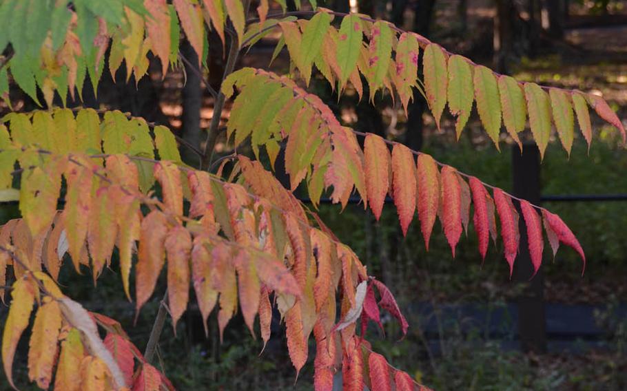
Fall color changes generally come later as you move south, but some regions still vary. It's best to watch Travel Wisconsin's Fall Color Report for peak colors. (Kevin Revolinski/Chicago Tribune/TNS) ()
Fall color changes generally come later as you move south, but some regions still vary. It's best to watch Travel Wisconsin's Fall Color Report for peak colors. (Kevin Revolinski/Chicago Tribune/TNS) ()
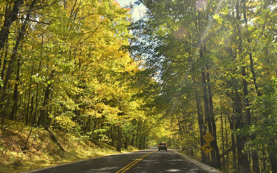
Kettle Moraine Scenic Drive follows the length of Kettle Moraine. (Kevin Revolinski/Chicago Tribune/TNS) ()
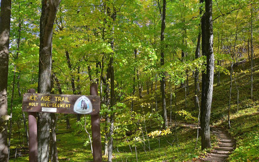
The Ice Age Trail traverses Kettle Moraine, but not only within the state forest. Here a segment passes over Holy Hill. (Kevin Revolinski/Chicago Tribune/TNS) ()
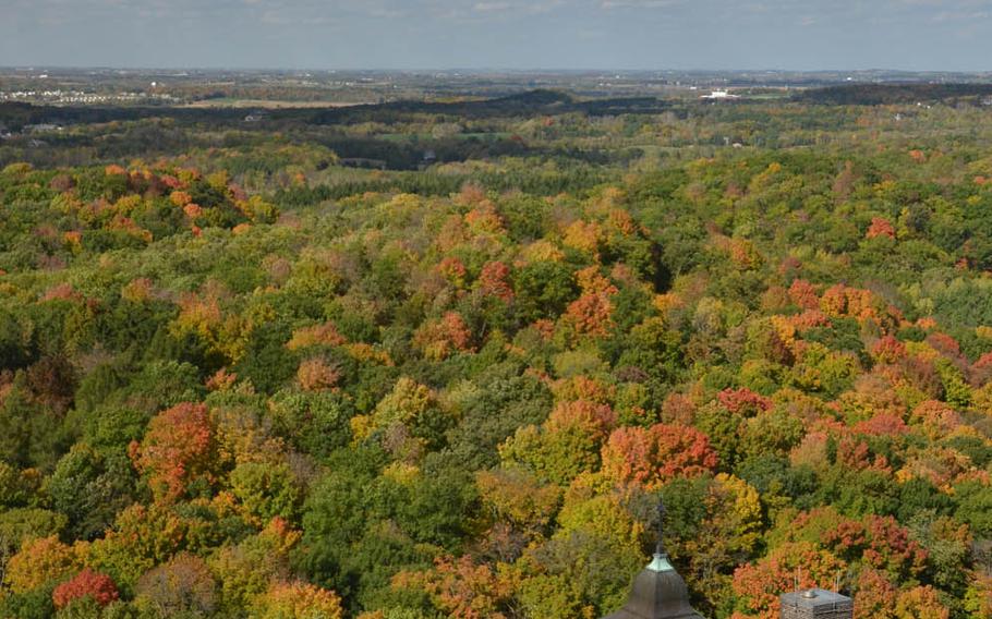
The view of fall colors stretches to the horizon from the steeple at Holy Hill. (Kevin Revolinski/Chicago Tribune/TNS) ()
Wisconsinites might grimace at how rough winters can get these days, but 20,000 years ago much of the state was under a sheet of ice thicker than a mile in some places. This Laurentide Ice Sheet extended south of Chicago. One of the most fascinating marks it left as the ice melted was the Kettle Moraine.
A "kettle" forms when debris from a grinding glacier gathers in a deposit as the ice melts away. In this case, a large chunk of ice at the center lasts a bit longer under the pile and when it finally does shrink, it creates a sunken bowl-shaped middle to the moraine. This long north-to-south area between the crushing forces of two major ice lobes — the Green Bay and Lake Michigan lobes — is so rife with them that the entire region took the term as a proper name.
Geneva and Pike Lakes are two of the largest kettles. The extensive collection of moraines, eskers and kames is a natural geological textbook, and much of it has been set aside as state forest. When the mosquitoes and hot temperatures are gone for the season, hikers head for Kettle Moraine for its excellent fall colors.
Five units make up Kettle Moraine State Forest: the Northern, Southern, Lapham Peak, Loew Lake and Pike Lake Units. Covering 56,000 acres, the units extend 100 miles along glacially altered lands from Elkhart Lake in the north to just south of Whitewater. But the state forest does not encompass the entire Kettle Moraine and several areas outside park borders make excellent hikes as well, particularly along the rustic footpath of the Ice Age National Scenic Trail, or IAT.
Raymond Zillmer, a Milwaukee attorney, had a dream. A passionate conservationist, he worked to expand the area preserved in Kettle Moraine State Forest, with the ultimate goal to have a long recreational trail. He created a foundation that would become the Ice Age Trail Alliance, the organizing force behind the Wisconsin-based hiking trail that has just over half of its 1,200 miles of proposed path completed along an area that roughly follows the edge of the last glaciers. Some of the longest continuous sections of the IAT are within Kettle Moraine.
Hard-core hikers may prefer through-hiking the IAT. The trail offers stretches of slightly more than 30 miles of trail in the Northern and Southern Units with shelters for overnight camping along the route. But shorter hikes for day-trippers or families with kids are plentiful as well.
The Zillmer Trails, connected by a spur trail to the Ice Age Visitor Center in the heart of the Northern Unit, have a combined 11 miles of grass and dirt paths. Trail loops vary in length from 1.2 to 5.4 miles, with the longest, the yellow trail, offering the most time in the woodland portions.
The Greenbush Trails share their name with a famous nearby kettle visible from the road. Start your hike either from the trail parking lot or a nice picnic area along the road. The green and purple loops run 3.6 and 5.1 miles, respectively, but there are three shorter options. All of them are wooded, but the longest route passes Bear Lake and its marsh and offers a look into a kettle.
In the Southern Unit, consider the IAT Segment starting from Whitewater Lake Campground. The path straddles moraines through the forest and looks out over an outwash plain at one point.
While the IAT often demands a shuttle or backtracking to your starting point, there are occasional loops formed by alternative connecting paths marked by white blazes rather than the characteristic yellow blazes. One such option is the Cedar Lakes segment, which forms a 3.8-mile lollipop when the white-blaze trail is used for a return route. Start south from the IAT parking lot at County Road NN, 4.3 miles northeast of the Pike Lake Unit.
Scenic overviews are typical along most of the trails, but a few true high points are recommended for fall colors. Parnell Tower is a 60-foot wooden structure at the highest point in the forest, a short walk from its parking lot and picnic area. If the climb is not enough, you can hike the 3.5-mile loop, which takes hikers through sharply rising and falling topography in thick woods. Part of the trail overlaps the Ice Age Trail as well.
Twenty-five miles west of Milwaukee, just off Interstate Highway 94, is Lapham Peak Unit. Known for an excellent cross-country ski trail system, the park offers the same routes, plus a short nature trail and accessible trail, to hikers. At the center of the park is a 45-foot observation tower on the highest point in Waukesha County.
As a glacier melts, meltwater often rushes straight down through the ice from high up on the surface, depositing glacial drift at the bottom of the tube as the water seeks its course underneath the glacier. These deposits are called kames, and in some cases they may grow to be tall conical hills that conspicuously tower above the surrounding terrain when the glacier is long gone. One such kame is Dundee Mountain, the tallest peak in the Northern Unit of the state forest. Summit Trail, a 1-mile nature trail, loops up and over the narrow peak offering excellent views.
Kames also make a pretty good place for an observation tower. The wooden platform at Powder Hill, a kame in the Pike Lake Unit, offers a 360-degree view over hardwood forest and Pike Lake as well as a look at another distant kame on the horizon: Holy Hill.
The Basilica of the National Shrine of Mary sits atop this kame, and visitors can climb up one of its towering steeples for fantastic views that include downtown Milwaukee on a clear day.
If you're not in the mood to hike or considering the route to your trail head, be aware that the Kettle Moraine Scenic Drive follows a 115-mile route from Elkhart Lake in the north to Whitewater Lake in the south using various local roads and county highways. All turns and routes are marked clearly so drivers won't lose their way. Most of the hiking destinations lie along this route as well. While the state forest offers rich woodlands full of fall colors, the occasional post-harvest farm field often features migrating birds, especially sandhill cranes.
If you go
Check out Travel Wisconsin's Fall Color Report to time your trip with peak colors. www.travelwisconsin.com/fall-color-report
Ice Age Trail Alliance,www.iceagetrail.org. The Ice Age Trail has its own trail guide and atlas available for purchase on its website.
The Basilica of the National Shrine of Mary, 1525 Carmel Road, Hubertus, 262-628-1838, www.holyhill.com
Information for all five units of the Kettle Moraine State Forest is available from the Wisconsin Department of Natural Resources website: http://dnr.wi.gov
Ice Age Visitor Center, N2875 Wisconsin Highway 67, Campbellsport; 920-533-8322
Lapham Peak Unit, W329 N846 C, County Road C, Delafield; 262-646-3025
Northern Unit, N1765 County Road G, Campbellsport; 262-626-2116
Pike Lake Unit, 3544 Kettle Moraine Road, Slinger; 262-670-3400
Whitewater Lake Visitor Center and Campground, W7796 Kettle Moraine Drive, Whitewater; 262-473-7501