Nock-Ten upgraded to tropical storm; could strike Philippines as a Category 3-equivalent typhoon. (www.NOAA.gov)
10:45 p.m. Monday, Dec. 26, Philippines time: Nock-Ten continues to barely hang onto Category 1-equivalent typhoon status and is pretty much done with the Philippines, heading into the South China Sea, according to the Joint Typhoon Warning Center. Only the very northeastern edges of Nock-Ten continue to brush the west coast, around Olongapo, former home to the Subic Bay Naval Station. Storm's center now lies 155 miles west of Manila, with Nock-Ten headed west-northwest at 14 mph packing 81-mph sustained winds and 98-mph gusts at center. Public Storm Warning Signal 2 has been lowered in all locales. PSWS # 1 only remains in Lubang Island, Bataan and Southern Zambales. Unless Nock-Ten does an about-face, this should be PST's final report on this surprising super typhoon late in the season.5 p.m. Monday, Dec. 26, Philippines time: Appears as if the worst is over. Nock-Ten remains a Category 1-equivalent typhoon (barely), and is moving toward the South China Sea away from land after its journey through South Luzon, according to the Joint Typhoon Warning Center. At 2 p.m., Nock-Ten was 84 miles west-southwest of Manila, steadly tracking west-northwest at 18 mph, still packing 81-mph sustained winds and 98-mph gusts at center. Multispectral image shows most of Nock-Ten out over water, with the eastern edges still giving Zambales in western Luzon a bit of a bad time. Public Storm Warning Signal 3 has been lowered for all areas, according to the national weather authority PAGASA. PSWS # 2 remains for Lubang Island and the western portions of Batangas, while Signal 1 is up for Southern Zambales, Bataan, the rest of Batangas, Cavite and northern portions of Occidental and Oriental Mindoro. Those will likely change over the coming hours. If it remains on its JTWC forecast track, Nock-Ten should remain a Category 1-equivalent typhoon for the next day or so as it heads northwest, then curve sharply southwest, picking up speed, decaying and finally dying out just southeast of Ho Chi Minh City late Thursday. Al Jazeera and other news agencies reported that as many as 300,000 people fled inlands from the storm, at least four people were killed, power was cut to five provinces and up to 50 domestic and international flights were canceled as a result of Nock-Ten. Flooding was present in many areas.11 a.m. Monday, Dec. 26, Philippines time: Nock-Ten is quickly losing its punch and has picked up forward speed, rapidly moving across southern Luzon toward the South China Sea, according to the Joint Typhoon Warning Center.
At 8 a.m., Nock-Ten was 77 miles south-southeast of Manila, moving west at 17 mph with 92-mph winds and 115-mph gusts at center. It was on course to pass 56 miles south of Manila, 55 miles south of Subic Bay Free Port and 87 miles south of Clark Free Economic Zone between noon and 3 p.m. Monday, moving rapidly and gradually diminishing as it heads back out over open water by Monday evening.
Public Storm Warning Signals remain in effect as follows:
-- Signal 3: Batangas, northern portions of Occidental and Oriental Mindoro including Lubang islands.
-- Signal 2: Metro Manila, Rizal, southern Quezon, Marinduque, Cavite, Laguna and the rest of Mindoro provinces.
-- Signal 1: Rest of Quezon including Pilillo Islands, Bulacan, Pampanga, southern Zambales, Romblon, Camarines Norte, Bataan and Calamian group of islands.
All this should be over soon.
5:15 a.m. Monday, Dec. 26, Philippines time: Nock-Ten is no longer a super typhoon, having been downgraded by the Joint Typhoon Warning Center to Category 3-equivalent typhoon status, and remains on track to cross southern Luzon Monday evening through southern Quezon, Laguna, Batangas and Cavite.
At 2 a.m., Nock-Ten was 154 miles east-southeast of Manila, headed west at 12 mph, packing 115-mph sustained winds and 132-mph gusts. It remains due to pass 42 miles south of Manila, 44 miles south of the former Subic Bay Naval Station and 77 miles south of the old Clark Air Base between 6 and 8 p.m. Monday, still packing 81-mph sustained winds and 104-mph gusts at center.
All public storm warnings remain the same as previously reported.
11 p.m. Sunday, Dec. 25, Philippines time: With Nock-Ten starting to move over land, the Philippines' national weather authority PAGASA has made some changes to public storm warning signals: -- Signal 4: Camarines Norte, Camarines Sur, southern Quezon.-- Signal 3: Catanduanes, Laguna, Batagnas, Marinduque, Albay and the rest of Quezon.-- Signal 2: Metro Manila, Rizal, Cavite, Oriental Mindoro, Sorsogon and Burias Island.-- Signal 1: Northern Samar, Zambales (including Subic), Pampanga (including Clark) and other areas of Luzon.
10:45 p.m. Sunday, Dec. 25, Philippines time: Though Nock-Ten has begun making its way over land, for the moment it remains a high-end Category 4-equivalent super typhoon, still packing 184-mph gusts at center, according to the Joint Typhoon Warning Center. At 8 p.m., Nock-Ten was 215 miles east-southeast of Manila, tracking west at 12 mph, with 150-mph sustained winds and 184-mph gusts as it passed over Catanuanes island. It's forecast to gradually turn northwest, slowly begin diminishing and and clip the south end of Luzon island. JTWC has Nock-Ten passing 45 miles south of Metro Manila, 43 miles south of the former Subic Bay Naval Station and 77 miles south of the old Clark Air Base between 2 and 6 p.m. Monday. It should remain a Category 2-equivalent typhoon with 92-mph sustained winds and 115-mph gusts at center. All PAGASA-issued public storm warning signals remain raised as previously reported. Expect changes within the hour.
8 p.m. Sunday, Dec. 25, Philippines time: Super Typhoon Nock-Ten, called Nina in the Philippines, has made landfall at 8 p.m. local time over Bato on Catanduanes island, according to the national weather authority PAGASA. All public storm warning signals remain the same.
5 p.m. Sunday, Dec. 25, Philippines time: It won't be long now. Nock-Ten continues churning at a furious pace, 155-mph sustained winds and 190-mph gusts, remaining a high-end Category 4-equivalent super typhoon.
Joint Typhoon Warning Center projects Nock-Ten to make landfall over Catanuandes island by about 8 p.m. local time, maintaining its same intensity.
At 2 p.m., Nock-Ten was 278 miles east-southeast of Manila, tracking west at 12 mph and due to start heading west-northwest, JTWC reports.
It should gradually diminsh as it makes its way west through Visayas into southern Luzon, with sights still set on near-direct approaches to Manila and the former Clark Air Base and Subic Bay Naval Station.
But expect Nock-Ten to remain a strong Category 2-equivalent typhoon as it passes 30 miles south of Manila and Subic and 62 miles south of Clark between noon and 8 p.m. Monday, still packing 104-mph sustained winds and 127-mph gusts at center.
Public Storm Warning Signal 4 has been raised for Catanduanes and Camarines Sur by the Philippines' national weather authority PAGASA. Signal 2 is up for Metro Manila and Cavite, while Signal 1 remains raised for Zambales and Pampanga, including Subic and Clark. Expect those to be increased as Nock-Ten moves inland.
10:30 a.m. Sunday, Dec. 25, Philippines time: Geez. Instead of weakening, Super Typhoon Nock-Ten has intensified slightly. It’s now packing 190-mph gusts as it edges closer, ever closer, to landfall over Catanduanes, forecast for sometime early evening, according to the Joint Typhoon Warning Center.
At 8 a.m., Nock-Ten was 342 miles east-southeast of Manila, rumbling west at 8 mph packing sustained 155-mph winds and 190-mph gusts at center. These are the sorts of storms that normally populate the region during July and August, rarely in December. But rare are the conditions so ripe – almost non-existent vertical wind shear and very warm sea-surface temperatures in the east Philippine Sea.
And forward speed has decreased, which delays the forecast passage of Nock-Ten through southern Luzon.
Nock-Ten is now on pace to pass 31 miles south of Manila, 32 miles south of the former Subic Bay Naval Station and 64 miles south of the old Clark Air Base between 3 and 7 p.m., about an hour later than previous forecasts. It should remain a powerful Category 2-equivalent typhoon, packing 104-mph sustained winds and 127-mph gusts as it approaches Metro Manila.
All public storm warning signals remain the same, according to the Philippines’ national weather authority PAGASA. Those may change with PST’s next update this evening.
9:30 a.m. Sunday, Dec. 25, Philippines time: A blessed Christmas to one and all from PST and hoping one and all in the Philippines, especially, are safe and happy.
Minor changes to the forecast track, which now brings Nock-Ten, still a super typhoon, within 30 miles of Manila and the former Subic Bay Naval Station and 62 miles south of the old Clark Air Base between 2 and 6 p.m. Monday.
Public Storm Warning Signal 3 remains raised for Catanduanes and Camarines Norte and Camarines Sur, right in the line of fire, according to the national weather authority PAGASA. PSWS Signal 1 remains raised for Manila, Pampanga (including Clark) and Zambales (including Subic).
Midnight Dec. 24, Philippines time: Public Storm Warning Signal 3 has been raised for Cataduanes island in southern Luzon, which is expected to take the brunt of Super Typhoon Nock-Ten when it makes forecast landfall Sunday afternoon or evening.
11 p.m. Saturday, Dec. 24, Philippines time: Little change. Nock-Ten should remain a high-end Category 4-equivalent super typhoon for at least the next few hours before gradually weakening as it approaches Samar and Visayas in east-central Philippines.
Slightly better news for Metro Manila and the former Subic Bay Naval Station and Clark Air Base – Nock-Ten’s latest Joint Typhoon Warning Center forecast track takes a bit further south than previously forecast, with slightly lower wind values.
At 8 p.m., Nock-Ten was 443 miles east of Manila, headed west at 8 mph, still packing 150-mph sustained winds and 184-mph gusts at center. If it remains on course, Nock-Ten is due to pass 40 miles south of Manila and Subic and 74 miles south of Clark between 2 and 6 p.m. Monday.
Nock-Ten, called Nina in the Philippines, is due to make landfall over Catanduanes by Sunday afternoon or evening, according to the national weather authority PAGASA. Public Storm Warning Signal 2 remains raised for parts of southern Luzon and northern Samar.
5 p.m. Saturday, Dec. 24, Philippines time: Nock-Ten has been classified a super typhoon, the fourth of the season so dubbed by the Joint Typhoon Warning Center. Nock-Ten is making its way west for a late Christmas Day rendezvous with Southern Luzon and a wet, windy Monday for Metro Manila and surrounding areas.
At 2 p.m., Nock-Ten was 490 miles east of Manila, traveling west-northwest at 9 mph and packing 150-mph sustained winds and 184-mph gusts at center, and is expected to remain a high-end Category 4-equivalent super typhoon for at least the next day, gradually diminishing as it moves west.
PST still projects a near-direct hit on Manila and the former Subic Bay Naval Station and a pass just south of the old Clark Air Base between 2 and 6 p.m. Monday, remaining a Category 2-equivalent typhoon, 92-mph sustained winds and 115-mph gusts as it roars past.
Public Storm Warning Signal 2 is up for Catanduanes in southern Luzon and Northern Samar in the Visayas, where landfall is expected late Sunday as a high-end Category 3-equivalent typhoon, and Signal 1 up for other areas of Luzon, according to the country’s weather authority PAGASA. Expect upgrades to those before long.
Noon Saturday, Dec. 24, Philippines time: It gets worse. Nock-Ten is now projected to approach super-typhoon status by the Joint Typhoon Warning Center. A high-end Category 4-equivalent beast forecast to peak at 150-mph sustained winds and 184-mph gusts sometime Saturday evening.
The silver lining to that is, Nock-Ten should weaken as it approaches the Philippines, but will still carry serious wallop, 104-mph sustained winds and 127-mph gusts as it crosses southern Luzon. Metro Manila and the former Subic Bay Naval Station remain in the crosshairs and cross just south of the old Clark Air Base between 2 and 6 p.m. Monday.
8 a.m. Saturday, Dec. 24, Philippines time: Wow. What at first appeared as if it would be just a middling storm is now brewing into a monstrous typhoon, due to peak at 138-mph sustained winds and 167-mph gusts early Christmas morning, a Category 4-equivalent storm, according to the Joint Typhoon Warning Center’s latest projections.
At 5 a.m., Nock-Ten was about 600 miles east of Manila and tracking west-northwest at 13 mph. If Nock-Ten remains on its current path, it’s due to make almost-direct hits on Manila and the former Subic Bay Naval Station and pass about 30 miles south of the old Clark Air Base, still packing a wicked punch, 115-mph sustained winds and 144-mph gusts at center.
9 a.m. Friday, Dec. 23, Philippines time: Nock-Ten could become a typhoon later Friday, and its peak intensity is now forecast to be 121-mph sustained winds and 150-mph gusts by early Christmas morning, just before making landfall over the central Philippines, according to the latest Joint Typhoon Warning Center projections.
Nock-Ten remains on course to pass almost directly over Metro Manila and the former Subic Bay Naval Station between noon and 5 p.m. Monday, and 25 miles south of the former Clark Air Base during that time frame, still packing a wicked punch, 92-mph sustained winds and 115-mph gusts at center as it crosses Luzon.
5 p.m. Thursday, Dec. 22, Philippines time: Tropical Storm Nock-Ten continues to give Yap headaches, but remains on course for giving the central Philippines far worse come Christmas weekend, according to the Joint Typhoon Warning Center.
Nock-Ten’s track continues to deviate further south, placing Manila and the former Clark Air Base and Subic Bay Naval Station in the path of north-quadrant winds which appear to be worse than south quadrants.
If Nock-Ten remains on its current path, it’s forecast to pass 13 miles south of Manila at 11 a.m. Monday, 48 miles south of Clark at 2 p.m. and 17 miles south of Subic at 4 p.m., still packing a fierce punch, 92-mph sustained winds and 115-mph gusts at center.
Nock-Ten is having its effects elsewhere as well. A high-surf advisory and small-craft advisory remain in effect for the Marianas Islands, including Guam, until 6 p.m. Saturday, while a tropical storm warning remains in effect for Yap, according to the National Weather Service on Guam. Yap remains bombarded by 45 mph winds as Nock-Ten passes by, just 17 miles west-southwest of Yap at 4 p.m. Guam time.
11 a.m. Thursday, Dec. 22, Philippines time: Now, it’s Manila in the crosshairs as Tropical Storm Nock-Ten’s forecast track has shifted further south, according to the Joint Typhoon Warning Center’s latest advisory.
If Nock-Ten remains on its current path, it’s forecast to pass directly over Manila at 1 p.m. Monday, 11 miles south of the former Subic Bay Naval Station at 6 p.m. and 40 miles south of the former Clark Air Base at 3 p.m., still packing a wicked punch: 110-mph sustained winds and 132-mph gusts at center.
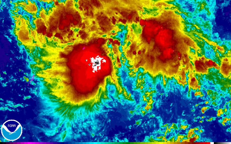
8 a.m. Thursday, Dec. 22, Philippines time: Nock-Ten has been upgraded to a tropical storm by the Joint Typhoon Warning Center and its forecast peak winds have increased sharply, hinting that it might hit the Philippines as a Category 3-equivalent typhoon. This could be bad, folks.
Nock-Ten continues tracking northwest at 14 mph about 186 miles southeast of Yap. JTWC reports the environment is favorable for Nock-Ten to peak at 115-mph sustained winds and 143-mph gusts by early Christmas morning as it makes its approach to the central Philippines over the weekend.
If Nock-Ten remains on its projected path, it’s due to pass just 12 miles north of Manila at noon Monday, 26 miles north of the old Clark Air Base at 2 p.m. and make an almost-direct hit on the old Subic Bay Naval Station at 4 p.m., still packing 104-mph sustained winds and 127-mph gusts.
So, it’s no longer heavy rain being the biggest threat. Nock-Ten is intensifying in terms of wind velocity, becoming a double-barreled threat.
9:45 p.m. Wednesday, Dec. 21, Philippines time: Tropical Depression 30W’s forecast track has drifted slightly south from PST’s original forecast, putting it on a path taking it closer to Metro Manila and the former Subic Bay Naval Station and Clark Air Base and a bit later on Monday.
Most immediately, a high-surf and small-craft advisory remain in effect for the Marianas Islands, including Guam, until 6 p.m. Thursday. A tropical storm warning is in effect for Yap, according to the National Weather Service on Guam.
If 30W remains on its current path, it’s forecast to pass just 13 miles north of Clark at 5 p.m. Monday, 43 miles north of Manila at 1 p.m. and 48 miles north of Subic at 7 p.m., still packing 58-mph sustained winds and 75-mph gusts at center. 30W is forecast to peak at 86-mph sustained and 104-mph gusts as it roars ashore late Christmas Day near Visayas and Samar in the central Philippines.
4 p.m. Wednesday, Dec. 21, Philippines time: Well, that didn’t take long. Joint Typhoon Warning Center has issued its first warning on Tropical Depression 30W. Model guidance remains in agreement on a track through northern Visayas and southern Luzon in the Philippines, which may get a very wet, windy Christmas.
And it appears as if Metro Manila and the former Clark Air Base and Subic Bay Naval Stations might end up in the crosshairs of what could become a Category 1 or 2-equivalent typhoon by Christmas or the day after.
One thing to note: The wind values in the northern quadrants for the moment appear stronger than the southern. If it remains on its forecast track, 30W is projected to pass 54 miles north of Manila at 10 a.m. Monday, 29 miles north of Clark at 11 a.m. and 61 miles north of Subic at 2 p.m. Monday, packing sustained 63 mph winds and 81 mph gusts at center.
1:30 p.m. Wednesday, Dec. 21, Philippines time: Joint Typhoon Warning Center has issued a tropical cyclone formation alert on 92W Invest, which could become a tropical depression within the next day. Japan Meteorological agency issued a tropical depression alert at 12:15 p.m.
Model guidance shows a track through northern Visayas and southern Luzon. It may remain a strong tropical depression or possibly become a weak tropical storm. Wind is not expected to be an issue; however, the storm could bring plenty of rain to the central Philippines. Too early to say definitively.
This would be the 30th numbered storm of the northwest Pacific’s tropical cyclone season. If it becomes a named storm, it will be called Nock-ten, Laotian for bird. PAGASA, the Philippines’ national weather authority, would name it Nina.
PST remains on watch.
4 p.m. Tuesday, Dec. 20, Philippines time: Manila and much of Luzon Island could be in for a wet Christmas if a disturbance near Chu’uk that the Joint Typhoon Warning Center is tracking develops into a tropical cyclone.
Model guidance is in pretty tight agreement that 92W Invest should track northwest, passing through the northern Visayas and southern portions of Luzon toward Manila as a strong tropical depression and/or weak tropical storm.
Though winds aren’t projected to be strong, rain is expected to be the major issue, if 92W Invest does develop and head in that direction.
92W Invest is having some effect on the Marianas Islands. A high surf advisory and small craft advisory are in effect until 6 p.m. Thursday, according to the National Weather Service on Guam.
South of the Equator, traffic is picking up along Australia’s northwest coast, a tropical cyclone forecast to pass just northeast of Port Hedland, while another disturbance, 90S Invest is lurking just west-northwest of Darwin. PST will keep watch.